
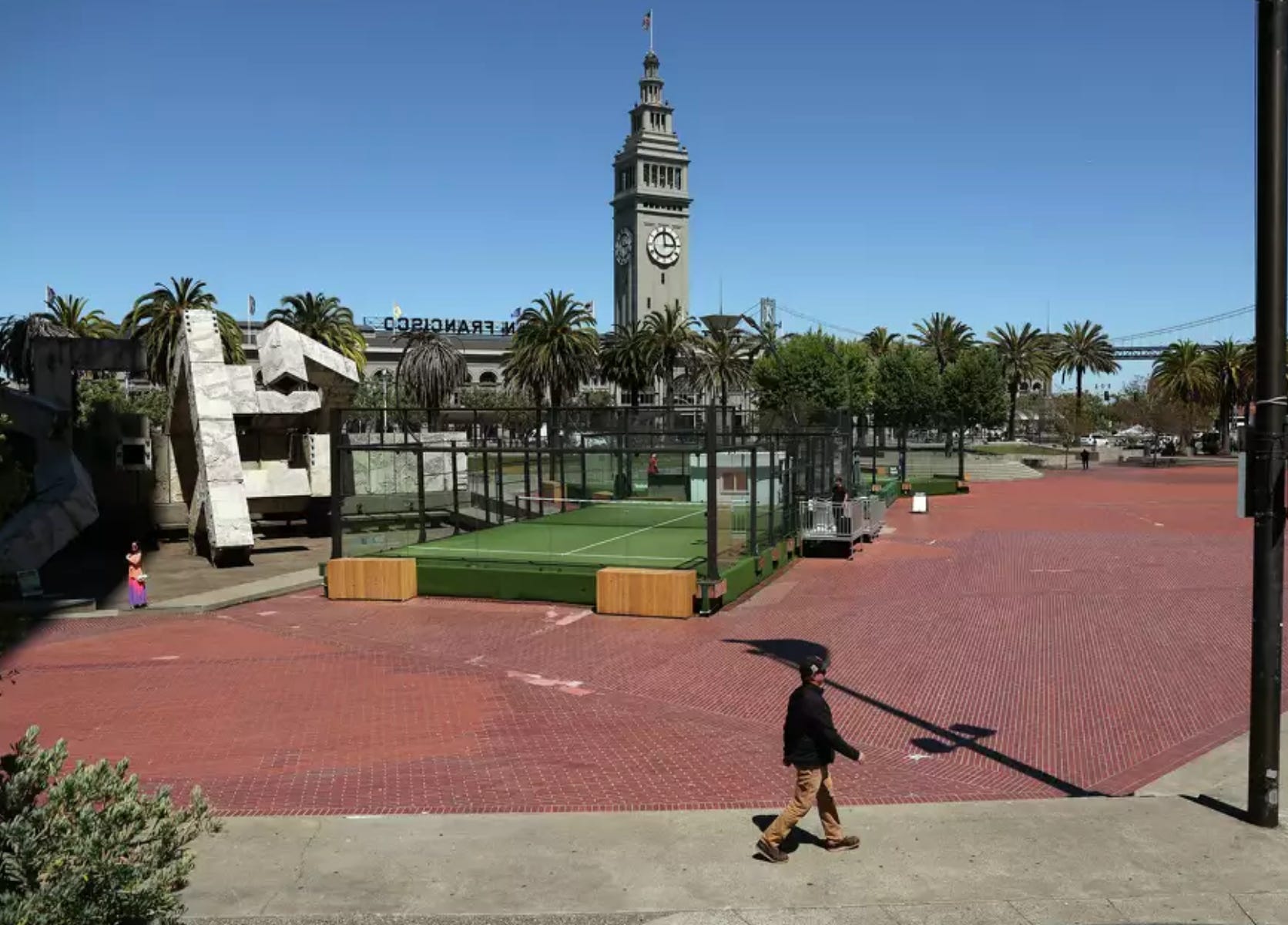
Embarcadero Plaza
San Francisco has world-admired scenery, vistas, and open spaces. The new parks in the Mission Rock and Mission Bay neighborhoods along with Tunnel Tops in the Presidio all add gems to these exceptional assets. But there is still a noticeable lack of comfortable pedestrian havens that speak to the style and grace of European spaces. The Embarcadero Plaza project at the foot of Market Street gives hope for a park-like space scaled for residents, workers, and tourists to enjoy. Right now there is a mix of “things” (below) that degrade the plaza, including two padel courts, the tangled tubes of the Vaillancourt Fountain, and an ugly expanse of discolored and patched brick paving.
Formerly the head of the San Francisco Redevelopment Agency starting in 1959, Justin Herman and his gang were responsible for a wide variety of notorious projects that destroyed communities throughout the city, including the Western Addition where 10,000 people (predominantly Black) were displaced through the clearing of more than 60 blocks. Nowhere was the impact of “urban renewal” felt more than in the communities of The Fillmore and Japantown where massive relocations were coupled with the devastating Geary Boulevard depression that, to this day, is an unsightly and divisive element. Justin Herman’s urban planning hi-jinks in these and many sectors of the city finally caused the San Francisco Recreation and Park Commission to rename Justin Herman Plaza the Embarcadero Plaza in 2017. This is all to say that we need to get it right in these new projects; we have plenty of examples of how not to do it.
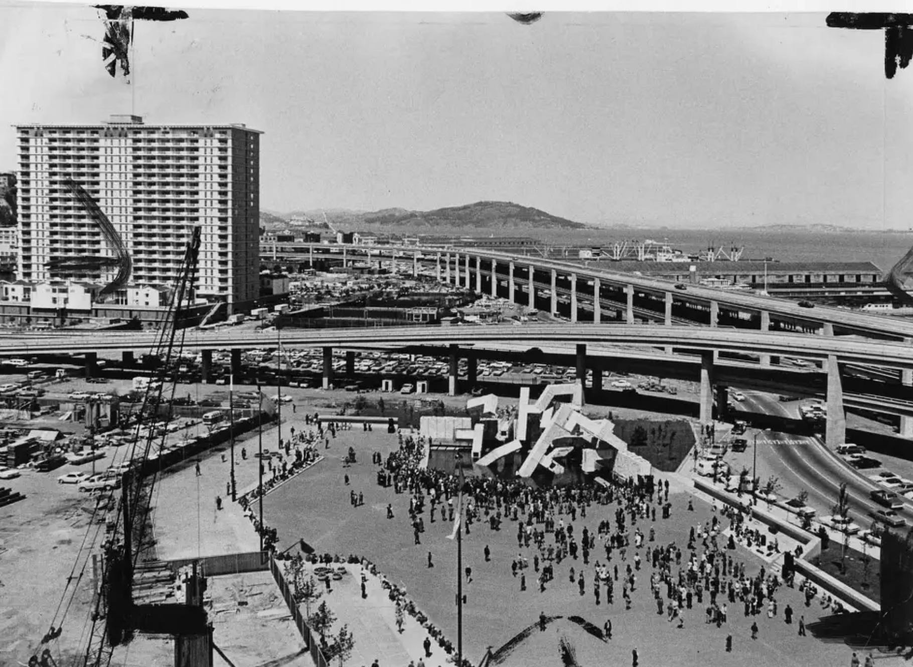
An influential report way back in 1962 put together by renowned landscape architect Lawrence Halprin and architects Don Carter, and George Rockrise, suggested that if the Plaza became a vibrant, alive, colorful place, used by day and night, it would '“send a tingle up the spine of Market Street.” While Halprin & Co.’s intentions were bold for the time, the spine of Market Street really never tingled to my knowledge. The plaza has frequently held demonstrations and gatherings over the years as well as a skating rink, but it never rose to the intentions cited in that 1962 report. Its low-water mark is arguably the installation of a phenomenally gross 45-foot-tall R-Evolution sculpture of a naked woman with sixteen motors in her chest to simulate breathing…brought to us by that bombastic event in the Nevada desert, Burning Man. Really?
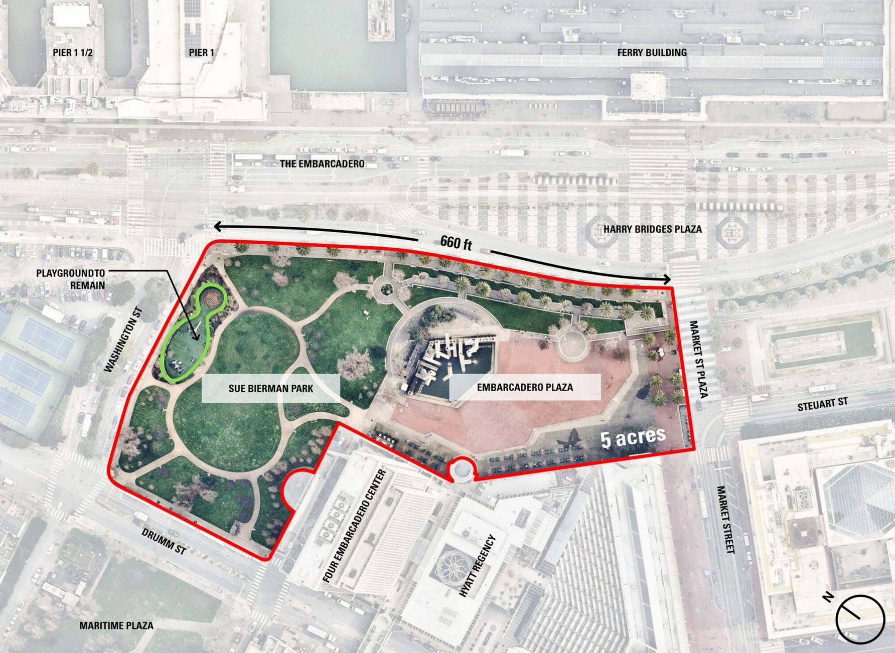
The owner of Embarcadero Center, BXP (formerly Boston Properties) and the City’s Park & Recreation Dept. have been working to explore a new bold concept for this 5-acre site which could give a big boost to the downtown revival. The boundaries would absorb the existing Sue Bierman Park, retaining the actively-used children’s playground. The site of the existing underused bocce court across the bottom of Market Street would ideally come into play as well, not to mention the totally underused Harry Bridges Plaza in the middle of the Embarcadero that fronts the Ferry Building and is currently a playground for skateboarders whose sport includes harassing pedestrians. Finally, what about those upper level promenades that wind their way through the four-building Embarcadero complex. I used to spend my lunch hour eating among the pleasant greenery and varied views on one of the levels. Why not rethink the contribution that important network of pedestrian ways offers.
But lets take a step back and take a look at some images I took of Bryant Park in New York City (below) a few years back. Named after the poet and editor William Cullen Bryant, it is located in the heart of the city at the back door of the main branch of the public library. It has a rich history, starting with the 17th century. In the 1930’s a new layout included lawns and promenades, but by the 1960’s it fell into serious decline becoming crime-ridden and a serious blight on the neighborhood. A major redesign in 1988-92 brought new life to the square. Fast forward to today: Bryant Park is one of the busiest and most successful urban parks in the world, hosting outdoor movies, fashion shows, and seasonal markets. Landscaping is a balance between paved and green zones that accommodate areas for chess, ping pong, cafes, bars, and an area just for children. And, what’s that? A newsstand? Of special note: The Bryant Park Corporation, formed in 1980, stands as a model for public-private partnerships. I would also add, a model for good urban design.


Now for a glance at some early proposals developed for our Embarcadero Plaza. The one at top left appears to be an outdoor sculpture museum, hardly a model for a diverse range of activities. On the top right we see another example of a collision of ill-defined spaces put together for eye candy no doubt. On the bottom left we see a super-charged fantasy of discordant pieces. What’s with the sweeping bridges connecting both sides of the Embarcadero like freeway ramps? The bottom right rendering gives us some hope, but again, there doesn’t seem to be any discipline to reaching any carefully thought out plan. It’s as though those tiny pedestrians on those paths will be wandering for hours trying to figure out why they even came. There are many talented folks at the Park & Rec group and in the offices of our local architects and landscape architects, but do we have the right team to be at the top yet? Do we need to cast a wider net with a competition? We can’t let this one slip away. Bryant Park shows what can be accomplished if a thoughtful and coordinated approach is there from the start. Let’s not go from zero to sixty miles an hour in a second. Admittedly, the conceptual work at the beginning is typically used as a series of marketing images. But too often they begin to take on a life of their own.


The Railyards
This project is right up there in terms of major importance in San Francisco as a gateway and mixed-use complex. Bounded by Mission Bay, Central SoMa, Oracle Park, and Showplace Square, it is linked to The Portal project which ultimately (and hopefully) will see Caltrain and High Speed Rail connected, underground, to the downtown Salesforce rail and bus terminal. Currently, the Caltrain station at 4th and King Streets is the front door to the site. Things have settled down a bit since the electrification of Caltrain. A fleet of sleek new trains has replaced the shabby diesel locomotives and passenger cars that used to test the nerves and health of the neighbors (and the pa
ssengers). For the past ten years the site has been the subject of a raft of studies. It is generally agreed that there should be a vital, high density, mixed-used neighborhood here that knits together the tattered edges of the railyards. How to do that is the real challenge.
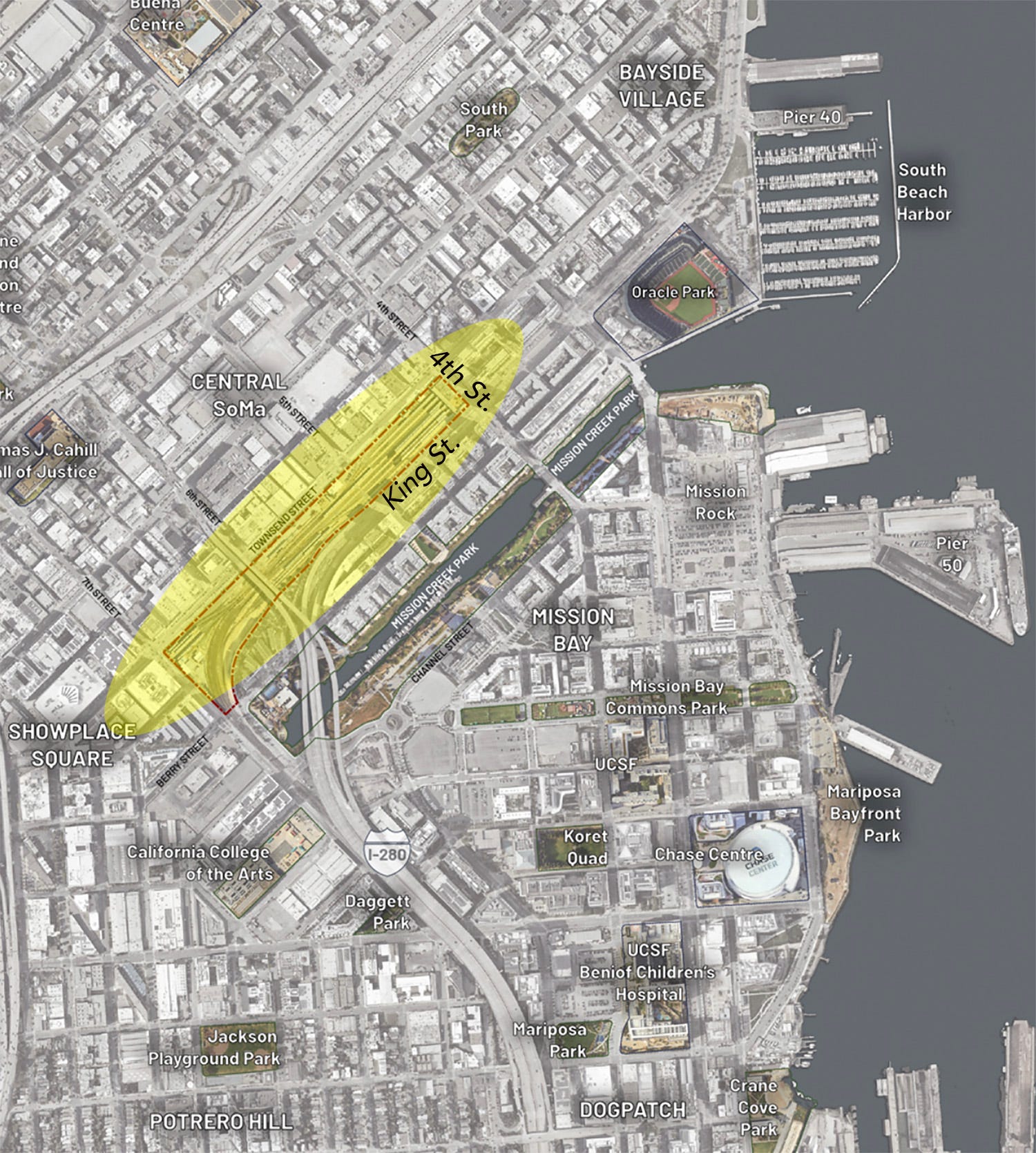
The project is a joint venture between Prologis and Caltrain. What is a Prologis you ask. It is a real estate investment trust (REIT for short) located on Pier 1 in San Francisco. They invest in logistics facilities. What are logistics facilities you ask. I had to have Google sort that one out. Apparently they are giant warehouses, distribution centers, and fulfillment hubs—designed to store, manage, and transport goods efficiently. Hopefully we don’t have PG&E doing the power grid. Prologis is the largest industrial real estate company in the world. “Its business strategy is focused on warehouses that are located close to huge urban areas where land is scarce,” according to an article in the 2020 issue of The Economist. Hmmm…warehouses, logistics facilities, railyards. It strikes me that we have some strange bedfellows here. Just looking at the rough diagrams one can only sense the warehouse feeling of the massing (below). Pieces of open spaces live 5-to-6 stories above ground on podiums. Previous studies were scaled in ways that had more to do with connections to the neighborhood both in scale and in the mix of activities. This version seems to me an attempt to max out the real estate footprint at the expense of livability.
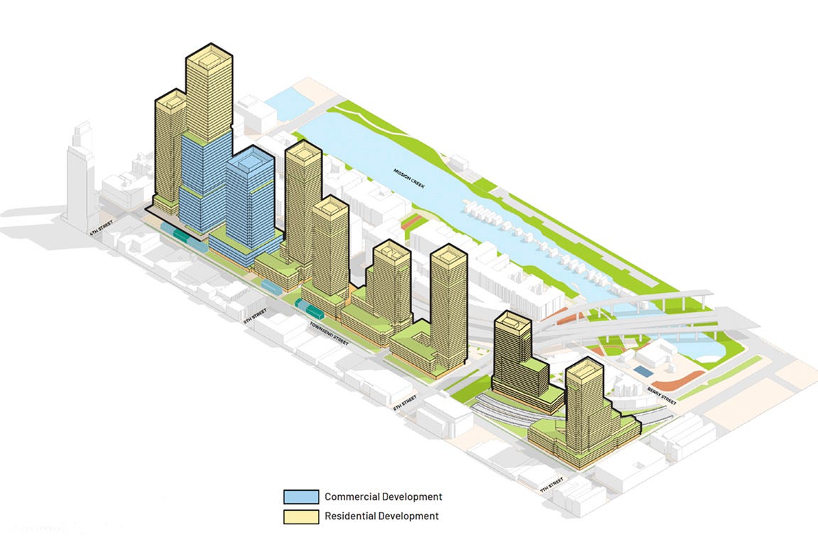
Prologis expects to include 7-to-8 million square feet at build-out on this 18 ½-acre property with the tallest tower reaching 850 feet. The site plan below includes some tight-looking plazas and parks. I’m wondering who will actually be promenading along Townsend Street.
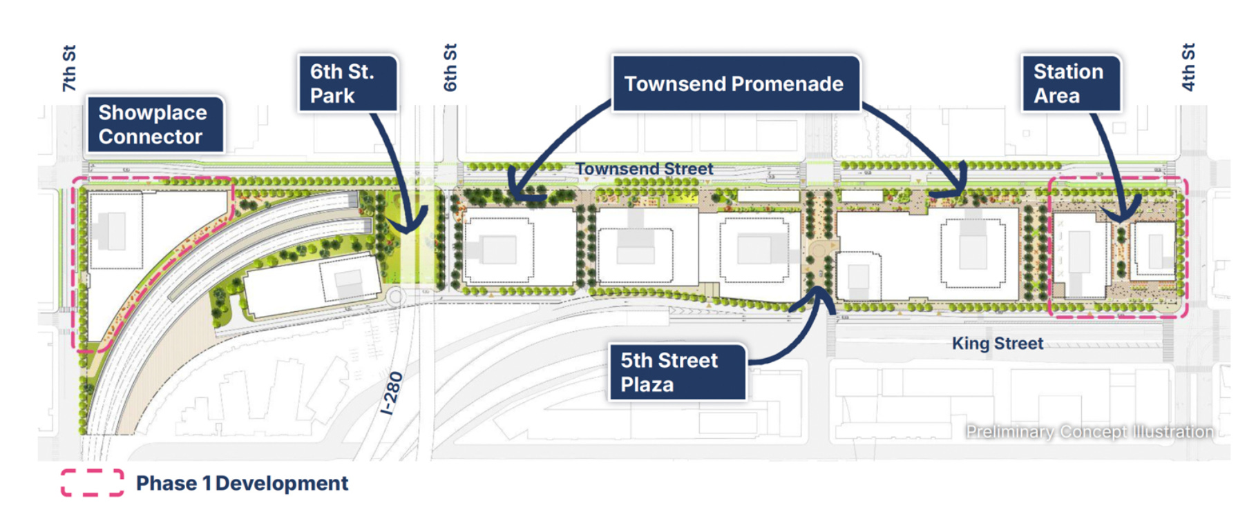
The preliminary renderings are well done, but for my money, they give the feeling of one more office park. The children’s playground is an afterthought. The new train station is buried in one of the towers when it should be celebrated and made one of the more prominent elements. I’m all for density, but sometimes it comes at the expense of including some of the features that Bryant Park has included, like fountains, a dining pavilion, a place to play chess or ping pong, or even a branch library with seating for reading. So maybe one has to downsize the expectations of those investors in the Prologis REIT.


Hallidie Plaza
This plaza is located at the entrance to the Powell Street Muni and BART stations on Market Street in the Union Square area of downtown. With all good intentions in 1967, landscape architect Lawrence Halprin, architects Mario J. Ciampi and John Carl Warnecke developed the scheme for Hallidie Plaza. This is (or should be) a major gateway for the City since it is a huge tourist destination. The Powell Street cable car turnaround and boarding area sits just adjacent. The BART and Muni station complex is one of the most active transit facilities in the region. Right now, Hallidie Plaza is an embarrassing mess of functions and circulation. The view on the left (below), shows the Flood Building and the open-air escalators connecting the plaza below with the street level. For years, the plaza has been inhabited by druggies and miscreants.One typically has to gird yourself for the trip up (or down) these escalators. The view on the right (below) shows the jumbled plaza with the shabby green-roofed food wagon. Rough-formed concrete retaining walls at the terraces add a further harshness to the setting.


John King, the former urban design critic for the San Francisco Chronicle, often bemoaned the lack of a real solution for Hallidie Plaza. The City’s Department of Public Works held a workshop a few years back that tried to come up with answers. But, as workshops go, this was another light touch that was a “design by committee” exercise.
A few years ago, I said okay, I’m going to take a whack at it and developed a series of 3D views (this was way before AI) of what might happen if it were to become something. Again, we’re talking conceptual only here. The scheme included a sizable information center, enclosed stations for both BART and Muni, a plaza for relaxing and events, a below-grade transit museum, and landscaped areas. The development was to be funded from the sale of air rights over the two city-owned parcels that straddle Cyril Magnin Street. A public-private entity was to be established for the whole development. I showed my concept to authorities oat the Union Square Alliance and SPUR (formerly the San Francisco Planning & Urban Research Association). It got a positive reception, but, clearly there would need to be an overriding entity that had the horsepower to put such a complicated package together. Maybe it’s time to knock on Mayor Lurie’s door. We desperately need a better face on transportation in the region to bring in more riders and to finally make something of this site.


There's almost too much to digest in here, but a TON of good ideas. Have you thought about a career in architecture & urban planning? Oh, that's right, you've been there & done that. Thanks for this great assessment of the San Francisco scene.